Matidor
All-in-one field service management software with GIS integration
What is Matidor? Complete Overview
Matidor is a comprehensive field service management platform that combines project management with GIS mapping capabilities. Designed for environmental consultants, field service teams, and project managers, it solves critical pain points like paper-based workflows, remote collaboration challenges, and inefficient data management. The platform offers real-time project tracking, document management, and location visualization - all accessible from both desktop and mobile devices. Target users include environmental service providers, construction firms, oil & gas companies, and any organization managing geographically distributed projects. Matidor stands out with its seamless field-to-office integration, intuitive interface, and sector-agnostic approach that requires no technical GIS expertise.
Matidor Interface & Screenshots
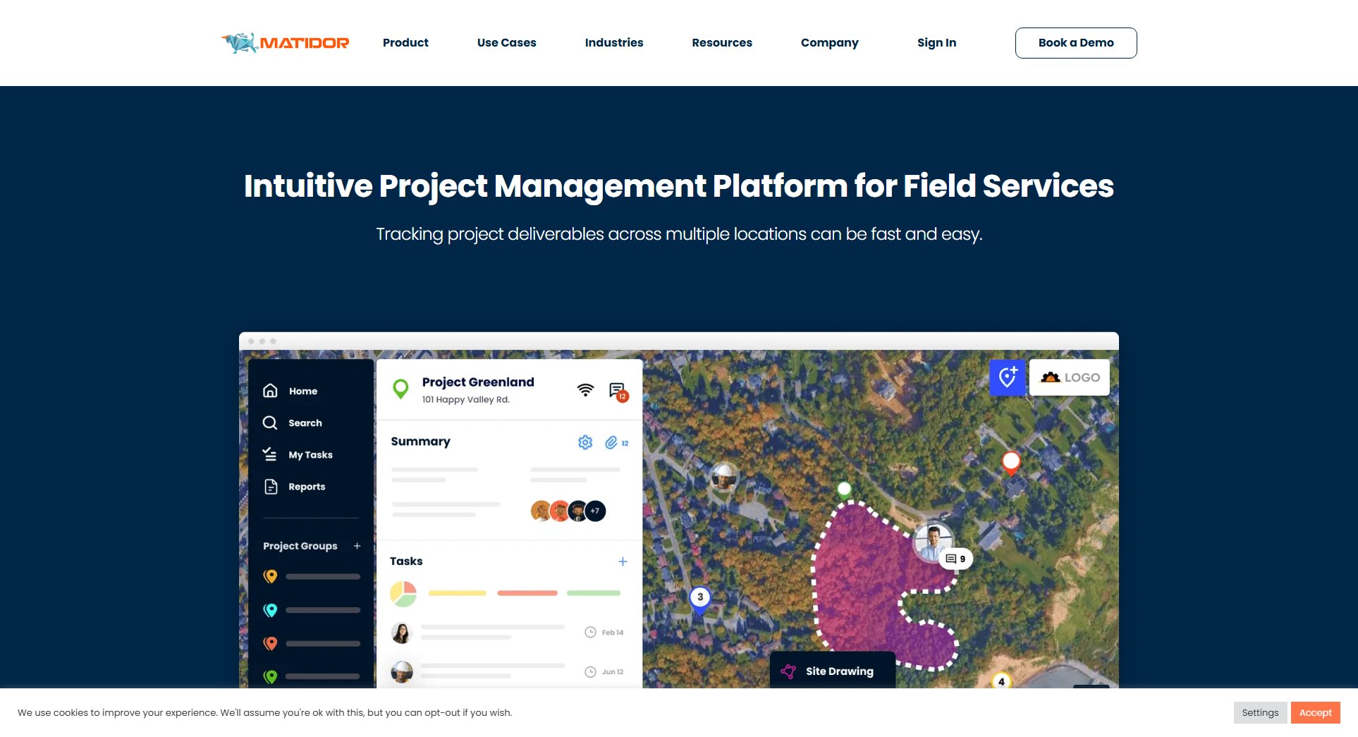
Matidor Official screenshot of the tool interface
What Can Matidor Do? Key Features
Integrated Mobile Field App
Matidor's mobile app provides full functionality in the field, allowing users to access project data, update information, and capture geotagged notes and photos. This eliminates the need for paper forms and delayed data entry. Field teams can view maps, access documents, and submit reports in real-time, ensuring office teams always have current project information.
GIS-Enabled Project Visualization
The platform displays all projects and assets on interactive maps, giving managers spatial context for their operations. Users can layer different data types (documents, permits, photos) onto map views, creating comprehensive visual project dashboards. This GIS integration helps identify location-based patterns and improves decision-making.
Unified Document Management
Matidor replaces paper-based systems with centralized digital document storage. All project files - permits, legal documents, reports - are stored in the cloud with version control. Advanced search and filtering make documents instantly accessible to authorized team members from any location.
Real-Time Collaboration Tools
The platform enables seamless communication between office and field teams through activity streams, task assignments, and notification systems. Stakeholders can track project progress, share updates, and address issues without email chains or meetings, significantly reducing project delays.
Customizable Access Controls
Matidor offers granular permission settings that let administrators control exactly what information each user or stakeholder can access. This is particularly valuable for projects involving multiple parties (clients, contractors, regulators) who need different levels of data access.
Best Matidor Use Cases & Applications
Environmental Site Assessments
Environmental consultants use Matidor to manage site investigation data, track sampling locations on maps, and maintain all regulatory documents in one place. Field teams capture observations in real-time, while managers monitor progress across multiple sites from the office.
Remediation Project Management
Cleanup contractors leverage Matidor's GIS capabilities to plan and track remediation activities. The platform helps visualize contaminant plumes, monitor treatment system performance, and maintain compliance documentation throughout multi-year projects.
Construction Site Oversight
Construction firms use Matidor to coordinate subcontractors, track daily progress against plans, and maintain all permits and inspections digitally. Superintendents access site documentation from their tablets, reducing trips to the job trailer.
How to Use Matidor: Step-by-Step Guide
Sign up for an account and set up your organization profile. Matidor offers guided onboarding to help configure your workspace, import existing projects, and establish user roles and permissions.
Create your first project by entering basic details and uploading relevant documents. Use the map interface to define project locations and boundaries by dropping pins or drawing shapes.
Invite team members and stakeholders to collaborate. Assign specific access levels to control what each person can view or edit. Field staff should install the mobile app for full functionality.
Begin tracking project progress through the activity dashboard. Field teams can update tasks, submit reports, and attach geotagged photos directly from the mobile app, with all data syncing instantly to the central platform.
Generate reports and export data as needed. Matidor allows customized reporting for different stakeholders, with options to share project snapshots, status updates, or detailed analytics.
Matidor Pros and Cons: Honest Review
Pros
Considerations
Is Matidor Worth It? FAQ & Reviews
No, Matidor is designed for non-technical professionals. The interface is intuitive and requires no prior GIS knowledge, though it offers powerful mapping capabilities for those who need them.
Matidor uses enterprise-grade security measures including encryption, access controls, and regular backups. Data is stored in secure cloud infrastructure with options for private cloud deployment available.
Yes, Matidor offers demos and trial periods. Contact their sales team to arrange a personalized demonstration based on your specific use case.
Matidor offers API access and can integrate with various business systems. Enterprise plans include custom integration options to connect with your existing tools.
