Free Online Mapping Tools
Easy-to-use map maker tools for daily mapping tasks
What is Free Online Mapping Tools? Complete Overview
Free Online Mapping Tools provides a suite of intuitive and free GIS mapping tools designed for students, researchers, professionals, and planners. These tools simplify day-to-day mapping tasks without requiring complex GIS software. Users can upload data in CSV, GeoJSON, or ESRI Shapefile formats and visualize it on various base maps, including OpenStreet Maps and satellite imagery. The platform supports a wide range of functionalities, from basic tasks like measuring distances and areas to more complex analyses like elevation profiling and geodata conversion. Whether you need to find postal codes, locate EV charging stations, or optimize solar panel angles, these tools offer practical solutions for everyday mapping needs.
Free Online Mapping Tools Interface & Screenshots
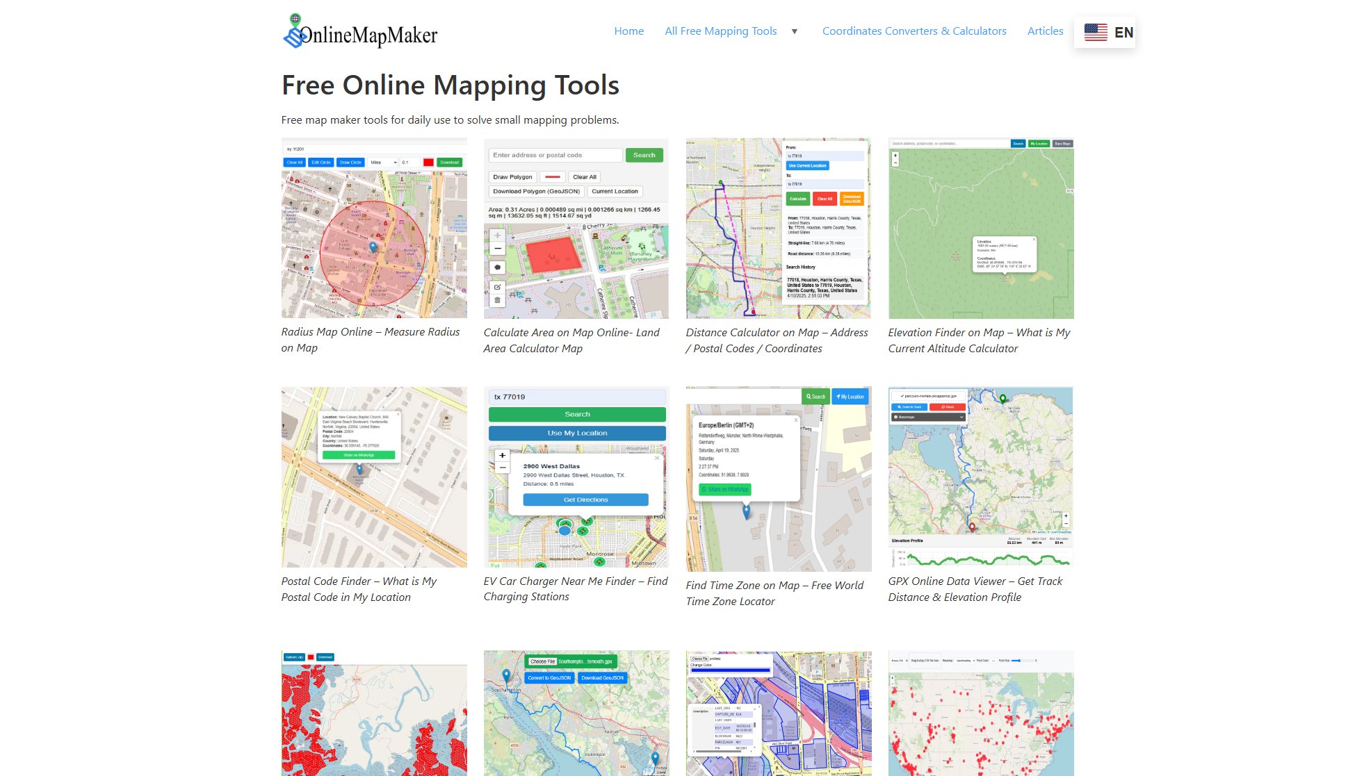
Free Online Mapping Tools Official screenshot of the tool interface
What Can Free Online Mapping Tools Do? Key Features
Radius Map Tool
Draw circles of any radius on a map at specified locations. Customize the circle's color, radius, and position, and download the map as a JPG file.
Area Calculator
Calculate the area enclosed by a polyline on a map in multiple units. Export the data in GeoJSON format for further use in GIS software.
Distance Calculator
Measure distances between two locations, providing both street/driving distance and straight-line distance. Download route data in GeoJSON format.
Elevation Finder
Determine the altitude of any point on the map using a 90-meter resolution dataset, offering approximate elevation under a 90×90 meter area.
Postal Code Finder
Locate your current postal code or zip code and share your address with friends and family via WhatsApp.
EV Charging Station Finder
Find nearby electric vehicle charging stations and get Google Maps driving directions to the nearest station.
Time Zone Locator
Identify the time zone for any address, postal code, or geographic coordinates by clicking on the map.
GPX File Viewer
Upload and view GPX files online to visualize outdoor activities like hiking, cycling, and running, including path, distance, and elevation profiles.
Shapefile Viewer
Display ESRI Shapefile (.shp) data on an online map and export the map for further use.
Geodata Converter
Convert GPS data from GPX format to GeoJSON format for compatibility with various GIS applications.
Best Free Online Mapping Tools Use Cases & Applications
Planning a Hiking Trip
Use the GPX File Viewer to upload a hiking trail GPX file and visualize the path, distance, and elevation profile to plan your trip effectively.
Finding Nearest EV Charging Station
Locate the nearest EV charging station using the EV Charging Station Finder and get driving directions to ensure your electric vehicle is charged efficiently.
Calculating Land Area
Measure the area of a plot of land using the Area Calculator tool to assist in real estate planning or agricultural projects.
Determining Solar Panel Angle
Use the Solar Panel Tilt Angle Calculator to find the optimal angle for solar panel installation based on your location and time of year.
Reverse Geocoding
Convert latitude and longitude coordinates into a readable address using the Latitude Longitude to Address Converter for fieldwork or research purposes.
How to Use Free Online Mapping Tools: Step-by-Step Guide
Navigate to the desired tool on the Online Map Maker website.
Input the required data, such as addresses, coordinates, or upload files like GPX or Shapefiles.
Interact with the map by drawing shapes, dropping pins, or searching locations to perform the desired task.
View the results directly on the map, including measurements, elevations, or routes.
Download or share the results in formats like JPG, GeoJSON, or PDF, depending on the tool.
Free Online Mapping Tools Pros and Cons: Honest Review
Pros
Considerations
Is Free Online Mapping Tools Worth It? FAQ & Reviews
Yes, all tools on Online Map Maker are completely free to use without any hidden charges.
You can upload CSV, GeoJSON, ESRI Shapefiles (.shp), GPX, and KML/KMZ files for various tools.
Yes, the tools are free for both personal and commercial use, but always check the terms of use for specific restrictions.
The elevation data has a resolution of 90 meters, meaning it provides an approximation within a 90×90 meter area.
There are no strict usage limits, but performance may vary based on server load and the complexity of your tasks.
