MapCSV
Transform CSV/Excel data into interactive maps instantly
What is MapCSV? Complete Overview
MapCSV by SharePlot is a powerful tool that transforms your CSV or Excel data into interactive, shareable maps within seconds. Designed for businesses, researchers, and data enthusiasts, it eliminates the complexity of geographic data visualization. The platform allows users to create professional-grade maps that display each datapoint with its associated data in an interactive table format. Perfect for creating business directories, store locators, and various location-based visualizations, MapCSV makes geographic data accessible and actionable. With its intuitive interface and quick processing, users can go from raw data to presentation-ready maps in minutes, without requiring any technical expertise in GIS systems.
MapCSV Interface & Screenshots
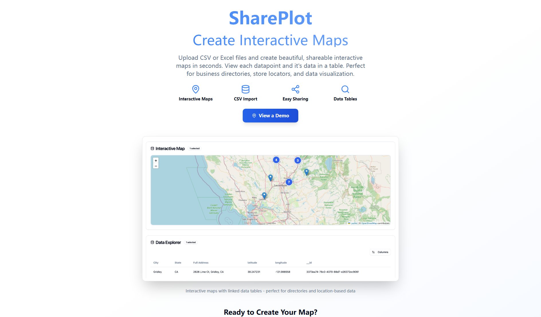
MapCSV Official screenshot of the tool interface
What Can MapCSV Do? Key Features
CSV/Excel Import
Easily upload your data in CSV or Excel formats. The system automatically processes your geographic data points and prepares them for mapping. Supports common address formats and coordinate systems for seamless integration.
Interactive Maps
Create fully interactive maps where users can zoom, pan, and click on data points. Each point reveals detailed information from your dataset, making it perfect for directories or location-based services.
Linked Data Tables
Every map comes with a synchronized data table that displays all your information. Users can explore data both visually on the map and numerically in the table for comprehensive analysis.
Easy Sharing
Share your interactive maps with colleagues or clients through simple links. No complicated export processes - your maps are instantly available online for viewing and interaction.
Google Integration
Quick start with Google account login eliminates lengthy registration processes. Leverages Google Maps technology for reliable, high-quality base maps and geocoding services.
Best MapCSV Use Cases & Applications
Business Directory
Retail chains can create interactive store locators showing all locations with relevant information like hours, services, and contact details, improving customer experience.
Sales Territory Mapping
Sales teams can visualize customer distributions, territories, and potential leads on an interactive map for better territory planning and management.
Event Planning
Event organizers can map attendee locations, venue options, and vendor locations to optimize event logistics and attendee experience.
How to Use MapCSV: Step-by-Step Guide
Prepare your data in CSV or Excel format with location information (addresses or coordinates) and any additional data you want to display.
Sign in with your Google account for quick access to the platform (no lengthy registration required).
Upload your prepared file - MapCSV will automatically process and geocode your location data.
Review the automatically generated map preview and adjust any settings if needed.
Share your interactive map via link or embed it on your website for others to explore.
MapCSV Pros and Cons: Honest Review
Pros
Considerations
Is MapCSV Worth It? FAQ & Reviews
MapCSV currently supports CSV and Excel file formats for data import. Ensure your file contains location data in address or coordinate format.
The free version handles typical dataset sizes well, but very large datasets may require optimization for best performance.
The free version offers basic customization options. More advanced styling features may be available in future premium versions.
You can share maps via direct links or embed them on websites. The platform generates these sharing options automatically after map creation.
MapCSV processes your data securely, but we recommend not uploading sensitive information as maps are designed for sharing.

