Soar
Explore the world with high-resolution satellite and aerial imagery
What is Soar? Complete Overview
Soar is an advanced mapping platform that provides users with high-resolution satellite and aerial imagery. It allows users to explore the Earth in detail with various map types, including satellite, hybrid, and base maps. The platform integrates data from multiple sources such as Sentinel 1A, Sentinel 2A, Sentinel 1B, Sentinel 2B, Landsat 8, and the International Space Station. Soar is designed for a wide range of users, from casual explorers to professionals in fields like geography, environmental science, and urban planning. The tool helps users visualize and analyze geographic data, track changes over time, and gain insights into different regions of the world.
Soar Interface & Screenshots
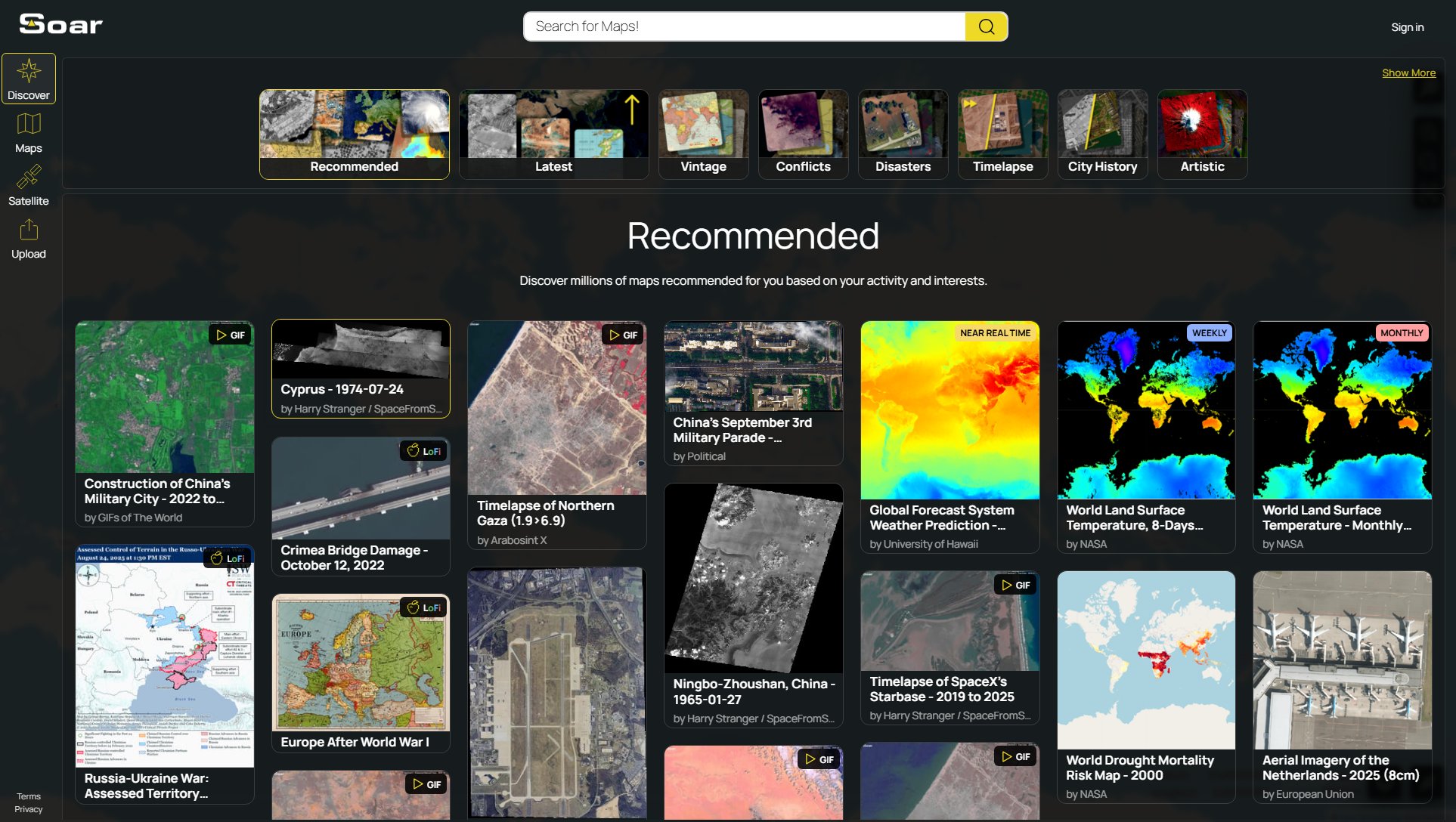
Soar Official screenshot of the tool interface
What Can Soar Do? Key Features
High-Resolution Satellite Imagery
Soar offers access to high-resolution satellite imagery from multiple sources, including Sentinel and Landsat satellites. Users can zoom in to see detailed views of any location on Earth, making it ideal for research, planning, and exploration.
Multiple Map Types
The platform supports various map types such as satellite, hybrid, and base maps. Users can switch between different views to suit their needs, whether for navigation, analysis, or visualization.
Real-Time Data Integration
Soar integrates real-time data from satellites like the International Space Station, providing up-to-date imagery. This feature is particularly useful for tracking changes in landscapes, weather patterns, and human activities.
Customizable Filters
Users can apply filters to focus on specific types of data or regions. This feature enhances the ability to analyze and compare different geographic features and changes over time.
User-Friendly Interface
Soar's intuitive interface makes it easy for users to navigate and explore maps. The platform is designed to be accessible to both beginners and advanced users, with straightforward controls and clear visuals.
Best Soar Use Cases & Applications
Environmental Monitoring
Environmental scientists can use Soar to monitor changes in ecosystems, track deforestation, and observe the effects of climate change. The high-resolution imagery provides detailed views of natural and human-made landscapes.
Urban Planning
Urban planners can utilize Soar to analyze city layouts, plan infrastructure projects, and monitor urban expansion. The platform's multiple map types and filters help in visualizing different aspects of urban areas.
Education and Research
Educators and students can use Soar as a learning tool to study geography, geology, and environmental science. The interactive maps make it easy to explore and understand complex geographic concepts.
Travel and Exploration
Travel enthusiasts can explore destinations before visiting, plan routes, and discover new places. Soar's detailed maps provide a virtual tour of any location in the world.
How to Use Soar: Step-by-Step Guide
Visit the Soar website and sign in to your account. If you don't have an account, you can explore the platform without signing in, but some features may require login.
Choose a map type from the available options, such as satellite, hybrid, or base maps. Each type offers different views and levels of detail.
Use the search or navigation tools to locate the area you're interested in. You can zoom in and out to adjust the view and explore different regions.
Apply filters to focus on specific data types or regions. This can help you analyze particular features or changes over time.
Download or share the maps as needed. Soar allows users to save their views and share them with others for collaboration or reference.
Soar Pros and Cons: Honest Review
Pros
Considerations
Is Soar Worth It? FAQ & Reviews
Yes, Soar offers a free version with basic features. Some advanced features may require a premium subscription.
Soar provides various map types, including satellite, hybrid, and base maps, each offering different views and levels of detail.
Yes, users can download and share maps for personal or professional use, depending on the terms of service.
Soar integrates data from multiple satellite sources, some of which provide near real-time imagery for certain regions.
Soar is useful for a wide range of users, including researchers, educators, urban planners, and travel enthusiasts.
