GeoFinderAI
AI-powered location detection from images with remarkable accuracy
What is GeoFinderAI? Complete Overview
GeoFinderAI is an innovative AI-powered tool that analyzes uploaded images to determine where they were taken with high accuracy. By examining visual elements such as architecture, landscapes, signage, and other geographical markers, the AI provides precise coordinates along with a confidence radius. This tool is particularly useful for travelers, photographers, journalists, and anyone curious about the origins of their images. New users receive 5 free location guesses, after which each analysis costs 10 tokens (equivalent to 10 cents). GeoFinderAI simplifies the process of identifying locations from images, making it accessible to both general users and professionals.
GeoFinderAI Interface & Screenshots
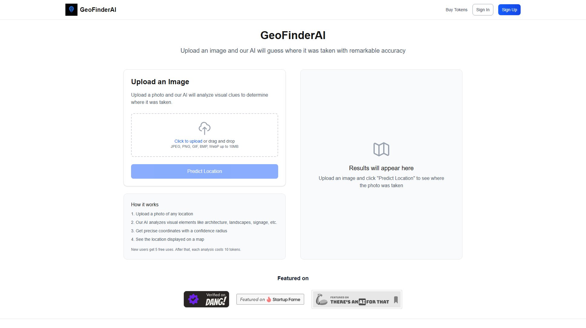
GeoFinderAI Official screenshot of the tool interface
What Can GeoFinderAI Do? Key Features
AI-Powered Location Detection
GeoFinderAI uses advanced artificial intelligence to analyze visual elements in images, such as architecture, landscapes, and signage, to determine the location where the photo was taken. The AI provides precise coordinates and a confidence radius, ensuring reliable results.
Multiple Image Formats Supported
The tool supports various image formats, including JPEG, PNG, GIF, BMP, and WebP, with files up to 10MB in size. This flexibility allows users to upload images from different sources without worrying about compatibility issues.
User-Friendly Interface
GeoFinderAI offers a simple and intuitive interface where users can upload images either by clicking or dragging and dropping. The process is straightforward, making it accessible to users of all technical levels.
Free Trial for New Users
New users receive 5 free location guesses, allowing them to test the tool's capabilities before committing to a purchase. This feature helps users evaluate the accuracy and usefulness of the tool.
Token-Based Pricing
After the free trial, users can purchase tokens to continue using the service. Each location guess costs 10 tokens (equivalent to 10 cents), with various token packages available to suit different needs and budgets.
Best GeoFinderAI Use Cases & Applications
Travel Photography
Travelers can use GeoFinderAI to identify the exact locations of their photos, helping them remember and share their travel experiences with precise details. This is especially useful for documenting trips and creating travel blogs.
Journalism and Research
Journalists and researchers can verify the locations of images used in their work, ensuring accuracy and credibility. This tool is valuable for fact-checking and investigative reporting.
Personal Curiosity
Individuals who come across unknown images or old photos can use GeoFinderAI to satisfy their curiosity about where the photos were taken, adding context and meaning to their collections.
How to Use GeoFinderAI: Step-by-Step Guide
Upload a photo of any location by clicking the 'Upload an Image' button or dragging and dropping the file into the designated area. Supported formats include JPEG, PNG, GIF, BMP, and WebP, with files up to 10MB in size.
Once the image is uploaded, click the 'Predict Location' button to initiate the AI analysis. The AI will process the image and analyze visual elements such as architecture, landscapes, and signage.
Wait for the AI to complete the analysis. The processing time may vary depending on the complexity of the image and the current server load.
View the results, which include precise coordinates and a confidence radius. The location will also be displayed on a map for easy visualization.
GeoFinderAI Pros and Cons: Honest Review
Pros
Considerations
Is GeoFinderAI Worth It? FAQ & Reviews
GeoFinderAI provides precise coordinates with a confidence radius, ensuring reliable results. The accuracy depends on the visual elements present in the image, such as architecture, landscapes, and signage.
GeoFinderAI supports JPEG, PNG, GIF, BMP, and WebP formats, with files up to 10MB in size.
New users receive 5 free location guesses to test the tool's capabilities before purchasing tokens.
Each location guess costs 10 tokens, which is equivalent to 10 cents.
Yes, the Plus and Pro plans include the ability to save your location guess history for future reference.

